SPC lists no valid watches after Watch 703’s window closes
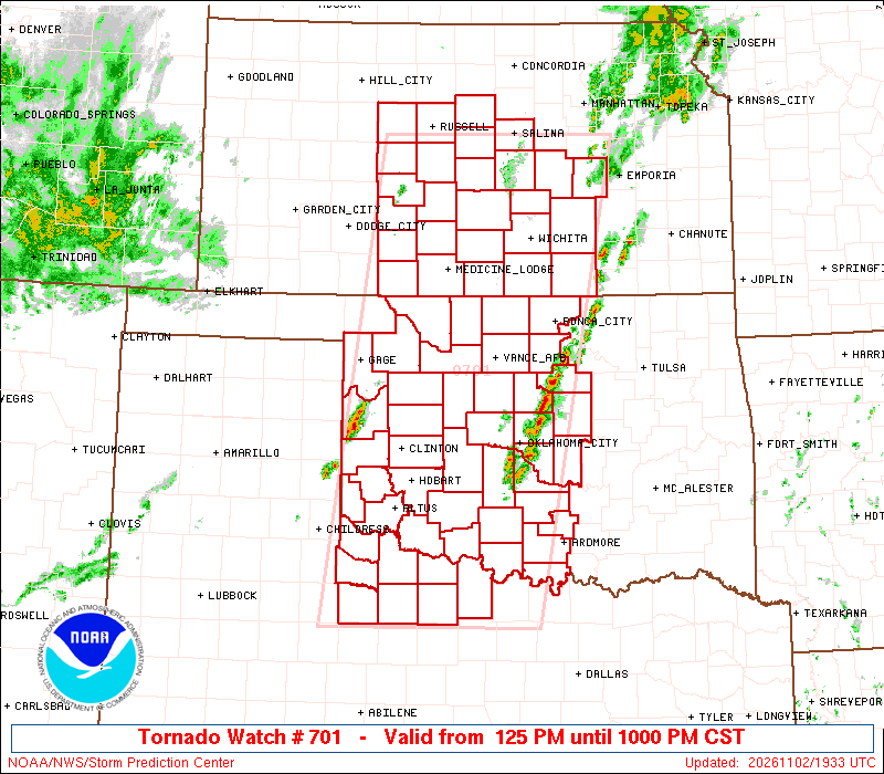
SPC’s 09:02 UTC listing says no watches are currently valid. This is not an all-clear for local warnings or hazards. The retained map shows Watch 701’s initial area.
Verified brief
The story in 60 seconds
At 09:02:07 UTC November 3, the Storm Prediction Center’s current-watch page reports no valid watches and identifies 703 as the most recently issued watch. Watch 703’s scheduled window ended at 3 a.m. CST (09:00 UTC). Watches 701 and 702 had already left the listing after their earlier scheduled windows.
This brief and the full story below are based on the disclosed sources. SearchTrends Daily’s interpretation appears later under “Our take.”
Full reporting
The complete story
Latest status: SPC’s current-watch page, updated at 09:02:07 UTC November 3, states that no watches are currently valid. It identifies Watch 703 as the most recently issued watch. This is a time-specific report of the official listing, not a claim about every local warning or all remaining storm hazards.
Watch 703’s published window ran from 7:35 p.m. CST November 2 to 3 a.m. CST November 3 (01:35–09:00 UTC November 3). It covered portions of northwest Arkansas, southeast Kansas, southwest Missouri and eastern Oklahoma. Its bulletin forecast possible tornadoes and damaging winds; that forecast does not establish observed impacts.
At the earlier 05:02 UTC review, Watches 701 and 702 were already absent from the current list. Their published windows had ended at 10 p.m. and 11 p.m. CST November 2, respectively (04:00 and 05:00 UTC November 3). Watch 703 had been issued while those two watches were still continuing, rather than as a newly issued replacement at their end.
Original Watch 701: SPC issued it at 1:25 p.m. CST November 2 (19:25 UTC) for portions of central and southern Kansas, western and central Oklahoma, and northwest Texas. The initial bulletin forecast tornado, wind and hail hazards. Subsequent status reports narrowed the guidance on where the threat continued. Those earlier county lists are now dated history, not current boundaries; the published update notes retain the progression.
KOCO’s Oklahoma report, reviewed with its 5:59 p.m. CST November 2 update, independently described severe-thunderstorm warnings in central Oklahoma and the then-current tornado watch. That earlier report is retained as local reporting context. It is not evidence of a current watch or a confirmed tornado touchdown.
Source perspectives
What other reporting adds
These are the reports, official records, and trend observations used to build the story. The note under each link explains exactly what it contributes.
Primary bulletin directly reviewed: issued 19:25 UTC, scheduled through 04:00 UTC November 3, portions of KS/OK/TX and possible tornado, wind and hail hazards.
Read original source ↗NOAA / NWS Storm Prediction CenterInitial county outline for Tornado Watch 701Primary initial county list, including the named examples in the article. Local updates may change the included area; the aviation outline is an approximation.
Read original source ↗NOAA / NWS Storm Prediction CenterCurrent convective watchesOfficial listing directly reviewed with update time 09:02:07 UTC November 3. It states no watches are currently valid and identifies 703 as most recently issued. This is time-specific SPC watch status, not a local all-clear.
Read original source ↗KOCO 5Tornado watch issued across Oklahoma, including the OKC metroIndependent local reporting, directly reviewed with a November 2 update time of 5:59 p.m. CST. Reports central Oklahoma severe-thunderstorm warnings and the tornado watch; does not establish a confirmed tornado touchdown.
Read original source ↗NOAA / NWS Storm Prediction CenterWatch 701 — initial radar/watch graphicOfficial initial graphic marked updated November 2 at 19:33 UTC, used unaltered as a dated image. Full original map is available here.
Read original source ↗National Weather ServiceUse of NOAA/NWS data and productsPrimary reuse policy: NWS information is public domain unless otherwise noted; unaltered official products may be displayed with source identification.
Read original source ↗NOAA / NWS Storm Prediction CenterWatch 701 status reports — report 3 valid 00:45–01:40 UTC November 3Dated continuing-threat guidance retained for the article’s earlier coverage. Local official watch-county notifications determine clearance information; the earlier county lists are not current alert boundaries.
Read original source ↗NOAA / NWS Storm Prediction CenterTornado Watch 702 — issued 23:50 UTC November 2Separate west-central/north-central Texas watch scheduled through 05:00 UTC November 3. Explicitly continues Watch 701 rather than replacing it.
Read original source ↗NOAA / NWS Storm Prediction CenterTornado Watch 703 — issued 01:35 UTC November 3Primary bulletin for portions of northwest Arkansas, southeast Kansas, southwest Missouri and eastern Oklahoma, scheduled through 09:00 UTC. At issuance it explicitly continued Watches 701 and 702; not a later replacement notice.
Read original source ↗SearchTrends Daily opinion
Our take
Analysis
What the evidence and search signal suggest
Our assessment: the newer listing closes the active-watch context followed in this briefing. It does not determine whether storms caused damage, injuries or tornadoes. Any account of those outcomes requires separate verified evidence. It also does not guarantee that another watch will not be issued after this review.
Analysis and commentary are SearchTrends Daily’s interpretation. They are intentionally separated from the sourced account above.
Meaning
Why this matters
A watch, a local warning and an observed storm impact are different kinds of information. The absence of valid SPC watches at this review does not establish that every local NWS warning has ended or that every location is free of risk.
The initial Watch 701 map and earlier guidance in this article document a specific reporting period. They should not be used as a current alert map. Refer to official local alerts for a particular location.
Background
How we got here
This is the November 2 afternoon and evening watch, numbered 701. The number and valid times identify the specific product. Reports about an earlier overnight watch are a different reporting period and should not be used to describe this afternoon’s area.
The initial graphic includes radar context and the watch outline. It is an official weather graphic, not a damage photograph or proof of a tornado on the ground.
Outlook
What is likely to happen next
This briefing records the watch sequence through the SPC listing updated at 09:02:07 UTC November 3. New watches or local warnings can be issued later. Consult the current SPC page and local NWS alerts for subsequent conditions. The existing update notes and initial map remain an archive of Watch 701’s coverage.
Image credit: NOAA / National Weather Service Storm Prediction Center. Unaltered initial radar/watch graphic for Tornado Watch 701, marked updated November 2, 2026 at 19:33 UTC. NWS material is public domain unless otherwise noted. The original file is used unchanged; the site may crop its display. The full official graphic and county outline are linked in the disclosed sources. This is a dated weather graphic, not an event photograph.
A conditional editorial assessment based on the evidence available at the review date, not a guaranteed outcome.
Live record
Updates to this story
SPC’s newer listing reports no currently valid watches
SPC’s current-watch page updated November 3 at 09:02:07 UTC states that no watches are currently valid and identifies 703 as the most recently issued watch. Its scheduled window ended at 09:00 UTC. Updated the headline and summary to close the active-watch context and condensed earlier reporting into dated history, while preserving the original publication time, initial Watch 701 map, sources and previous update notes. This does not establish that all local warnings or hazards have ended.
Watches 701 and 702 leave the current listing after scheduled windows
SPC’s current-watch page updated November 3 at 05:02:09 UTC no longer lists Watches 701 or 702, after their scheduled 04:00 and 05:00 UTC end times. Separate Watch 703 remains listed through 09:00 UTC for portions of Arkansas, Kansas, Missouri and Oklahoma. The headline and current-status summary have been revised; earlier guidance and the initial Watch 701 map remain dated history. This is not a regional all-clear or a claim that every local warning has ended.
SPC report 3 further reduces the continuing-threat county list
Added the complete county lists from SPC status report 3, valid 6:45–7:40 p.m. CST November 2 (00:45–01:40 UTC November 3): seven Kansas counties, 23 Oklahoma counties and four Texas counties. The article distinguishes this threat guidance from official county-clearance notices, retains the earlier status report as dated context, and preserves the original publication time and initial map.
SPC narrows continuing-threat guidance; separate Texas Watch 702 issued
At 6 p.m. CST November 2, SPC status report 2 listed fewer counties where the severe-weather threat continued within Watch 701. This guidance is valid through 7:40 p.m. CST; official county clearances require local watch-county notices. We also added the separately issued Watch 702 for west-central/north-central Texas through 11 p.m. CST. Watch 701 remains listed through 10 p.m. CST. The original 19:33 UTC map remains clearly dated, and the original publication time is preserved.



Commentary
What we think
The clearest way to close a weather briefing is to identify the official status and review time, while keeping archived maps and forecasts distinct from current alerts and confirmed impacts.